MEDIA RELEASE
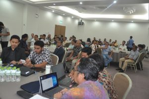
 Autoridade Nacional do Petróleo e Minerais (ANPM) has conducted first technical seminar on Integrated Airborne Geophysical Survey Project (IAGS) implementation on 16 February 2017 at Timor Plaza Dili. The objective of this seminar was to bring together various geologists and geophysicist from the ANPM, IPG, TIMOR GAP, PT. Karvak, the APG – as the sub-consultant who is currently conducting the survey to discuss about the utilization of the interpretation of the geomorphological features in the geomorphological map to identify geology of onshore Timor Leste and briefly look at the progress of the gravity survey as part of the Integrated Airborne Geophysical Survey project implementation.
President of ANPM, Gualdino da Silva in his welcome remarks said that this was the event that the Geologists and Geophysics of Timor-Leste can bring together all knowledge, understandings, and observations about the geology of Timor-Leste for the future.
“We all are coming from different background Universities, some graduated from Australian University, Brazilian University, Indonesian University and others universities, now we all think about Timor-Leste, today we are going to see the first geomorphological map of the Timor-Leste, to contribute our knowledge to our nation,” said Gualdino da Silva.
Gualdino da Silva added that it was a good opportunity for all of us to discuss and further contributing ideas to refine and retune the recently prepared geomorphological map of Timor-Leste.
During the seminar, the Management of PT. Karvak Nusa Geomatika Indonesia, the company who is managing the implementation of the IAGS project in Timor-Leste also presented the overall progress of this project implementation which is currently still ongoing.


